
 February 11, 2016 | gcaptain
Fred Pickhardt
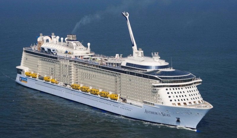
The Anthem of the Seas departed Bayonne, New Jersey last Saturday with about 4,500 guests and 1,600 crewmembers for what was scheduled to be a 7-day roundtrip cruise to the Bahamas. But during Sunday the vessel was sailing southward to a scheduled port call at Port Canaveral, Florida when it encountered a large, hurricane-force storm off of Cape Hatteras, North Carolina, forcing the Captain to lock down the ship as they rode it out. Royal Caribbean’s Anthem of the Seas in fairer weather. Photo credit: Royal Caribbean
Although Royal Caribbean has apologized to guests and crew and promised to strengthen its storm avoidance policy, the company still maintains that the weather last Sunday “far exceeded” forecasts. Let’s just take a look:
Weather Forecasts
As early as Wednesday afternoon (Feb 3), the NOAA 96 hour forecast chart was showing a rapidly deepening low forming east-southeast of Cape Hatteras early Sunday(Feb 7) reaching storm force by early Monday morning.
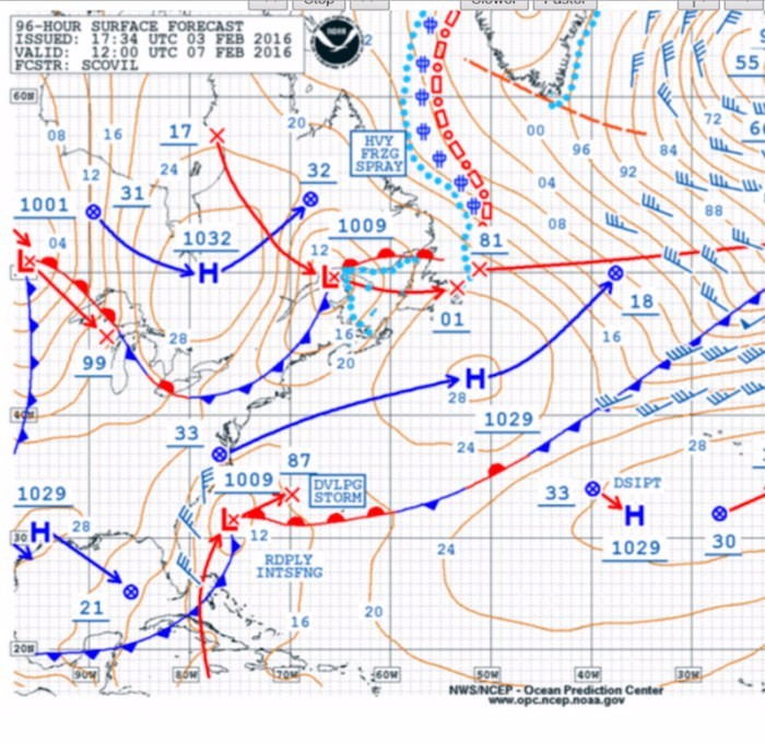 NOAA OPC 96 Hour Surface Forecast for Sunday morning 7 Feb 2016
Updated forecasts late Friday night indicated that storm force winds likely would occur closer to the North Carolina coast than the earlier forecast by late Sunday with conditions reaching hurricane force winds by early Monday.
By Saturday evening the updated NOAA Forecast chart issued just after midnight Saturday night indicated hurricane force winds with waves to 24 feet should be expected just off the Carolina coast by Sunday evening instead of early Monday morning.
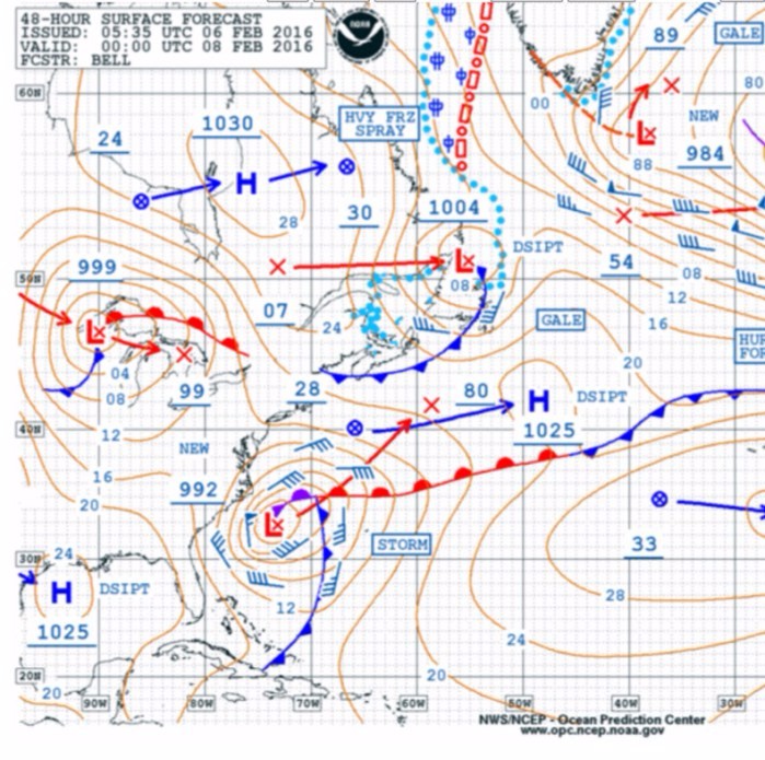 NOAA OPC 48 hour Surface Forecast for Sunday Evening
Role of the Gulfstream
The warm waters of the Gulfstream move up the US Coast from the Florida Straits and pass close to Cape Hatteras before turning eastward. The warm water in conjunction with cold air moving off the East Coast during winter often provides the dynamics to produce rapidly deepening storms off the US East Coast. In addition, when strong winds blow over strong currents moving in the opposite direction waves tend to shorten in length and increase in height. Near the north wall of the Gulfstream this is a well known phenomena where there is a higher risk for rouge waves during these conditions.
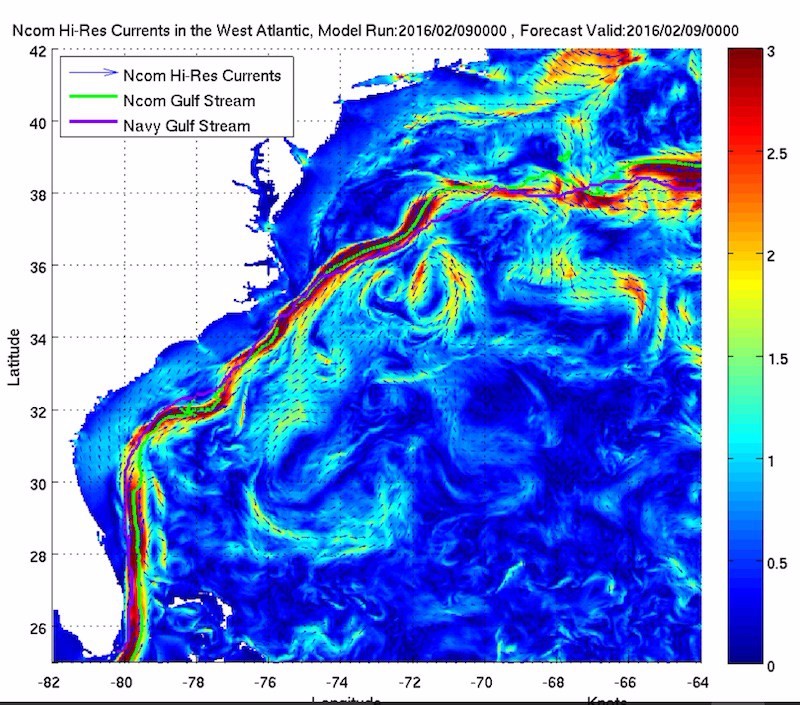 NOAA Gulf Stream Forecast
Vessel Track
As of this writing, I have not seen the actual position reports of the Anthem of the Seas so it would be difficult to say what track options were available to the master or what decisions were made. Given that the early forecasts suggested storm force conditions with the heaviest weather developing overnight Sunday into early Monday, perhaps the voyage plan might have taken the vessel clear of this area before the onset of the worse conditions.
Forecast updates issued late Friday night indicated that the area of storm force winds would likely occur closer to the coastline but the heaviest conditions still developing Sunday night and early Monday. By late Saturday night, the voyage was already underway when the updated forecast indicated that the storm would produce hurricane force winds with seas over 20 feet.
The storm did, in fact, deepen rapidly during Sunday with hurricane force winds and waves to over 30 feet developing by early Sunday evening just off the North Carolina Coast when the vessel encountered severe weather conditions near where the Gulfstream comes closest to the North Carolina coast.
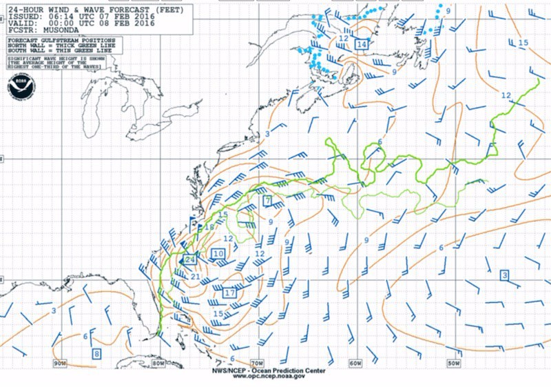 NOAA 24hr wind wave forecast for Sunday evening
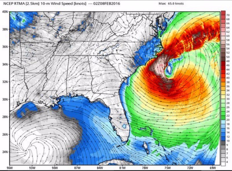 Hi Res 10 meter winds 9pm Sunday 7 Feb 2016 Image credit weatherbell.com
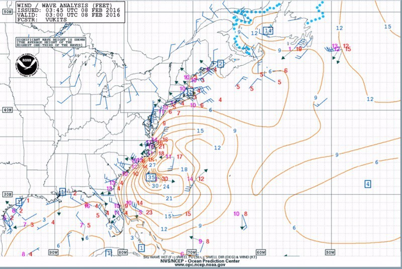 NOAA Wind and Wave Analysis 10PM Sunday 7 Feb 2016
Related Articles
Anthem of the Seas Caught in Extreme Storm Off U.S. East Coast
Coast Guard to Investigate Cruise Ship’s Wild Ride into Hurricane-Force Storm
‘Anthem of the Seas’ Float-Out at Meyer Werft [VIDEOS]
Meyer Werft Delivers Royal Caribbean’s Anthem of the Seas
“Sandy” Surpasses 1991 “Perfect Storm” – Wave Height Analysis
Recommended For You
Can a Wärtsilä Vasa 32 Diesel Really Self-Destruct?
NOL/APL… a missed opportunity for Maersk?
Carnival Forms Cruise Industry Strategic Partnership in China
In World With Too Much Crude Oil, Tanker Owners Reap Billion-Dollar Windfall


