 gcaptain | May 25, 2017 by Bloomberg
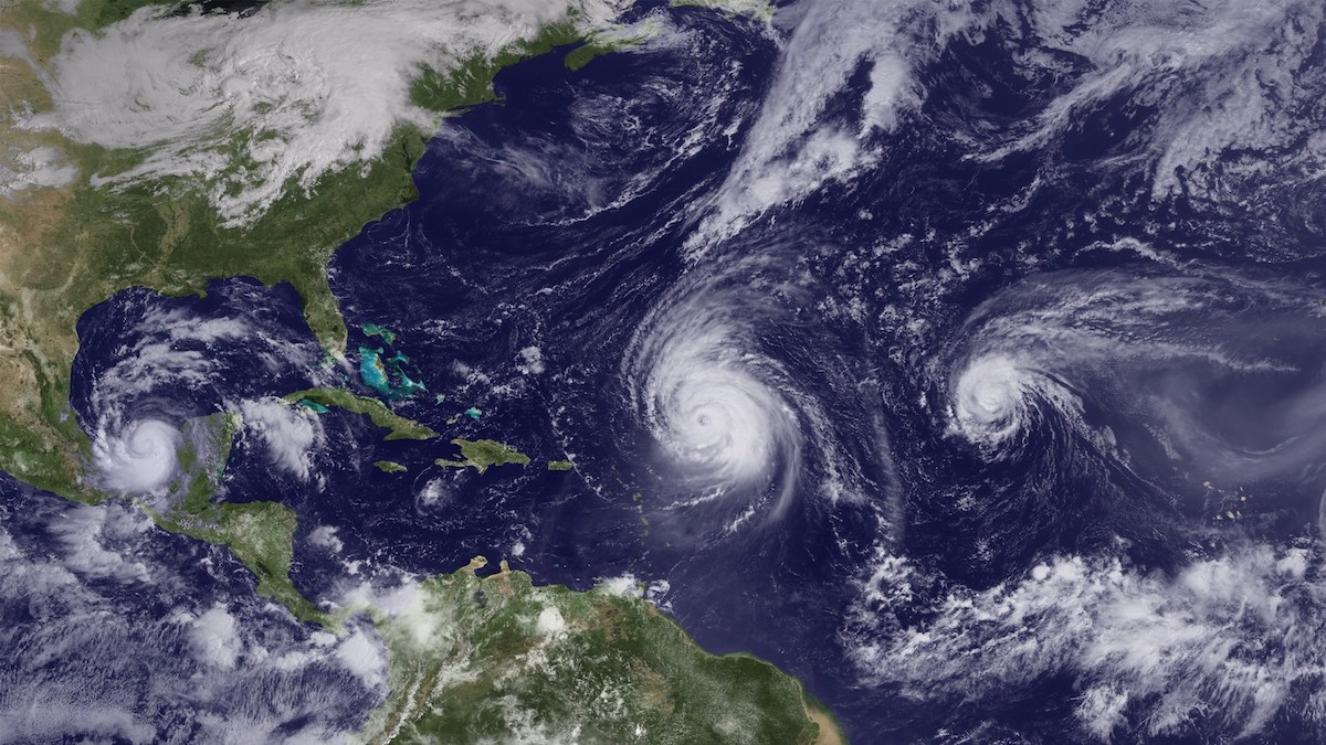
By Brian K. Sullivan (Bloomberg) — The Atlantic hurricane season will likely churn out an above-average 11 to 17 named storms, in part due to fading odds than an El Nino will form in the Pacific.Hurricanes Karl, Igor and Julia, from left to right, pictured on Sept. 16, 2010. Photo credit: NOAA
Of storms that emerge during the six-month season that begins June 1, five to nine will reach hurricane strength with winds of 74 miles (119 kilometers) per hour, the U.S. National Oceanic and Atmospheric Administration said Thursday. Two to four may become major systems reaching Category 3 or stronger on the five-step Saffir-Simpson scale.
The Earth’s most powerful storms can threaten lives, destroy property and move global energy and agricultural markets. An estimated $28.3 trillion worth of homes, businesses and infrastructure is vulnerable to hurricane strikes in the 18 U.S. Atlantic coastal states, according to the Insurance Information Institute in New York.
“There is a potential for a lot of Atlantic storm activity this year, ” Ben Friedman, acting NOAA administrator, said on a conference call. “We cannot stop hurricanes but we can prepare for them.”
The U.S. hasn’t been struck by a major system since Hurricane Wilma in 2005, said Dennis Feltgen, spokesman for the U.S. National Hurricane Center in Miami. In September, Hurricane Matthew killed at least 585 people, most of them on Haiti, making it the deadliest storm since Wilma. Matthew went on to graze the U.S. East Coast, causing widespread flooding across the South before making landfall in South Carolina.
In an average season, the Atlantic spins off 12 storm systems. A year ago, the U.S. predicted 10 to 16 would form while the season eventually saw 15 storms.
El Nino
Last month, Colorado State University predicted the Atlantic would produce 11 named storms. A system is named when winds reach 39 mph and it becomes a tropical storm. The university, which pioneered seasonal hurricane forecasts, will update its outlook next week.
Meanwhile, the specter of a Pacific Ocean El Nino hangs over all hurricane forecasts. El Ninos can make it harder for hurricanes to form across the Atlantic by increasing wind shear that weakens storms. Earlier this month, the U.S. Climate Prediction Center lowered the odds of El Nino forming to 45 percent from 50 percent in April.
A weak or nonexistent El Nino and above-average water temperatures in the tropical Atlantic is driving the above-average storm forecast, Friedman said.
In addition, warm water provides fuel for budding storms, said Gerry Bell, hurricane seasonal forecaster at the U.S. Climate Prediction Center in College Park, Maryland.
“Right now, there is not much of an indication at all that the season will be below normal,” Bell said. “It really is a combination of factors this year that point to a more active season.”
See Also: U.S. Lowers Odds of a Market-Moving El Nino Forming in Pacific
Storms can wreak havoc on agricultural markets in Florida, the second-largest producer of orange juice behind Brazil, and the top domestic grower of cane sugar.
And while energy traders also closely watch forecasts, a surge in onshore fracking for natural gas has lessened the impact of bad weather on markets. Offshore drilling in the Gulf of Mexico will account for 4.1 percent of total U.S. gas production this year, down from 14 percent about a decade ago, Energy Information Administration data show. In addition, storms Katrina and Ike destroyed many old drilling rigs and platforms, which were replaced with equipment better able to withstand storm forces.
“The point is just because it is not a major hurricane doesn’t mean that it’s not dangerous, doesn’t mean it isn’t deadly, doesn’t mean we don’t need to be prepared for it,” Friedman said.
The U.S. is using a new hurricane model this year that has delivered more accurate tracks and intensity forecasts in tests, Friedman said. The newest geostationary weather satellite, GOES-16, launched last year, will be moved to watch both the Atlantic and the eastern U.S.
In another change, the National Hurricane Center will issue storm surge watches and warnings, as well as time-of-arrival graphics to better alert people to pending storm conditions, said Mary Erickson, deputy director of the National Weather Service.
Flooding, the deadliest part of hurricanes, “is often overlooked because folks are focused on wind,” Erickson said.
Separately, the U.S. also predicted 14 to 20 named storms would form in the eastern Pacific, mainly off Mexico. The eastern Pacific storm season began May 15.
© 2017 Bloomberg L.P


 ο ψηφοφόρος της κλανιόλας
 η εποχή ζητά ενσυναίσθηση, συνείδηση και συμμετοχή, πολιτική ανασκόπηση
 γεωπολιτική για καμένους εγκεφάλους


