
 Strange Maps
Over a year ago by FRANK JACOBS
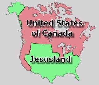
This map started popping up after the 2004 Presidential election in the US, when George W. Bush got re-elected (with a clear majority this time). Democratic challenger John F. Kerry only won a handful of states, mainly on both coasts – where the electorate is more liberal-leaning than in the more rural ‘flyover’ states in the middle. This map demonstrates the depth of the political divide between both sides.
This map can be found all over the internet. I lifted it off a blog called beancounters.
Strange Maps #3
Got a strange map? Let me know at strangemaps@gmail.com.
MOST POPULAR
Top Vets Urge Dog Owners to Stop Buying Pugs and Bulldogs
47% of Jobs Will Disappear in the next 25 Years, According to Oxford University
A Disturbing 1995 Prediction by Carl Sagan Accurately Describes America of Today
An Ancient Device Too Advanced to Be Real Gives Up Its Secrets at Last


